
Colorear cada región
La intensidad del color transporta el valor. La opción correcta para tasas, porcentajes y cifras per cápita, ya ajustadas al tamaño o la población.
Abrir la plantillaA blank Tennessee county map to print, and a builder to fill it with your own data. Download the free outline of all 95 counties, or upload a spreadsheet and publish an interactive Tennessee map you can embed anywhere.
Los 95 counties, con un trazado limpio. Imprímelo, coloréalo o insértalo en un documento — sin cuenta y sin atribución.
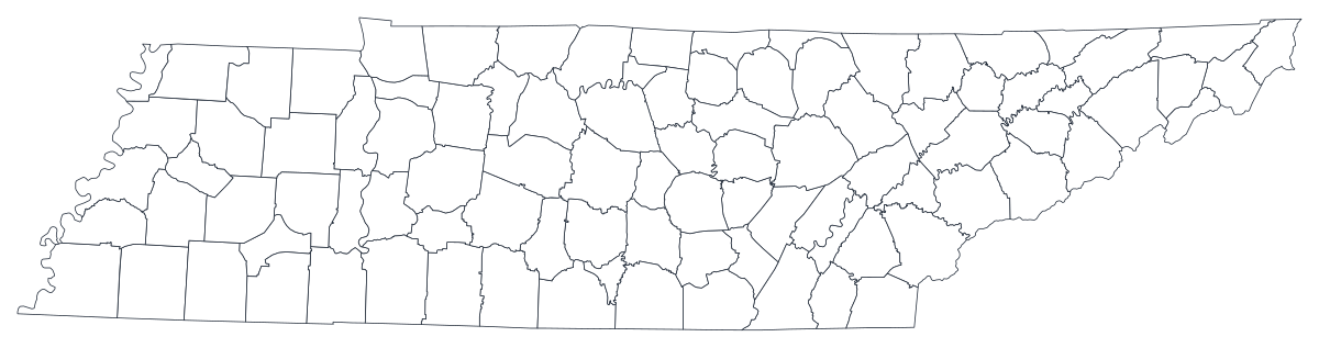
Libre para cualquier uso, incluidos el comercial y el educativo. Generado a partir de los mismos límites que usa el editor.
Descargar SVGTennessee divides into 95 counties, and the state has been thinking of itself in three parts for so long that the division is written into its constitution and drawn on its flag. East Tennessee is the Appalachian end — ridges, valleys and the Cumberland Plateau, with Knoxville, Chattanooga and the Tri-Cities strung between them. Middle Tennessee is the Nashville basin and the highland rim around it, and it is where almost all of the state's recent growth has gone: Williamson, Rutherford, Wilson and Sumner counties have been among the fastest-growing in the country. West Tennessee is flat delta farmland running down to Memphis, which sits in the far corner of the state in Shelby County. A county map of Tennessee is nearly always a picture of those three Grand Divisions and of the four metros pinned to their corners.
Colorea las regiones cuando tu cifra es una tasa; dimensiona un marcador cuando es un recuento. Invertirlo es la forma más común de que un mapa engañe.
La intensidad del color transporta el valor. La opción correcta para tasas, porcentajes y cifras per cápita, ya ajustadas al tamaño o la población.
Abrir la plantillaUn símbolo por región, escalado según el valor. Úsalo para recuentos y totales, donde colorear la superficie solo redibujaría el mapa de población.
Abrir la plantillaCírculos dimensionados por el valor sobre el contorno. Funciona bien cuando unas pocas regiones dominan y las pequeñas se perderían en un color.
Abrir la plantillaDepartment of Health indicators, Department of Labor and Workforce Development figures, Department of Education report-card data, Boyd Center population projections and Division of Elections returns are all published by county.
Unemployment rate, uninsured share, opioid dispensing rate, graduation rate, share of the vote, median household income. A rate is already adjusted for how many people live in a place, which is what shading a region needs.
East, Middle and West are meaningful units here in a way regions in most states are not — they have different economies, different politics and different histories. On a county map the three-way split is visible without drawing a single boundary.
Tennessee history is a required school subject and the 95-county map is a standing exercise. The free outline above prints cleanly at any size.
Shade by a raw count and the map is Shelby, Davidson, Knox and Hamilton dark and everything else pale. Use symbols or bubbles sized by the count instead.
Nashville and Davidson County share one government, but Memphis is smaller than Shelby County, Chattanooga smaller than Hamilton, and the Nashville metro reaches across thirteen counties. Mapping a city figure onto a county shape will overstate it every time.
Flooding, forest cover, air quality on the Cumberland Plateau and Tennessee Valley Authority reservoir effects all follow topography and watersheds. County lines cut across all of them.
Pickett, Van Buren, Moore, Hancock and Lake counties each have around five thousand residents or fewer, so suppressed cells are routine in health and education releases. A map that is mostly grey is a worse bar chart — rank the counties you do have.
De la hoja de cálculo al mapa publicado, paso a paso.
The free outline above is a plain SVG of all 95 counties — print it, or drop it into a document. To build with data, open the PlotSet Tennessee (counties) template, which comes with sample data already bound.
One row per county: the county name or its five-digit FIPS code in the first column, your number in the second. Tennessee's state code is 47, so every county code starts 47 and no leading zero can be lost.
Import a CSV or Excel file, paste from a spreadsheet, or connect a Google Sheet so the map can be refreshed when the source updates.
Shade the counties for a rate, or switch to symbols or bubbles for a count. Same geography, same data, different encoding.
Sequential for a low-to-high measure, diverging only when a real midpoint exists — the state average, zero change, a 50 per cent line. Four to six steps read more precisely than a smooth gradient.
Publish for a live interactive map with a tooltip on every county, or export a PNG, SVG or PDF for a report or a deck.
Empieza con la plantilla de Tennessee y sus datos de ejemplo, y luego sustitúyelos por los tuyos.
Abrir la plantillaCómo debe ser la columna de lugares y dónde encontrar datos que ya coincidan.
McMinn, McNairy, DeKalb and Van Buren are written several different ways across state and federal files — with a space, without one, and with varying capitals. This map's geometry carries them as "Mc Minn", "Mc Nairy", "De Kalb" and "Van Buren", so normalise case and spacing on both sides of the join, or match on FIPS.
Nashville and Davidson County have run as one metropolitan government since 1963; Lynchburg is consolidated with Moore County and Hartsville with Trousdale County. City-level and county-level figures for those three are the same number, so using both in one chart double-counts.
Washington, Jackson, Madison, Monroe, Montgomery, Warren, Wayne, Franklin, Lincoln, Greene, Jefferson, Union, Perry and Marion are all Tennessee counties and all names used elsewhere. Any multi-state file must be filtered to state 47 before joining, or rows from Missouri and Georgia will land on Tennessee shapes.
Only Missouri touches as many. It matters for regional analysis: the Tri-Cities reach into Virginia, Chattanooga into Georgia and Alabama, Memphis into Mississippi and Arkansas, and Clarksville into Kentucky. Several of the state's metros are mostly out of state, so a Tennessee-only map cuts them in half.
The Boyd Center for Business and Economic Research at UT is the usual first stop for population and economic series; the Department of Health, the Department of Labor and Workforce Development, the Department of Education, the Secretary of State's Division of Elections and the Census Bureau's ACS all publish county tables directly.
Shelby and Davidson counties together hold about a fifth of the state. Shade a raw count and the map is those two counties, whatever the measure was supposed to be. Anything that grows simply because more people live somewhere should be a sized symbol.
They are one government and one set of numbers. A file that carries both will either double-count the largest county in Middle Tennessee or leave one of the two rows unjoined and grey.
The plateau and delta counties cover a lot of paper and hold few people, so on a shaded map they take visual weight their populations do not justify. Readers read area as importance — say so in the caption.
With several counties under six thousand residents, health and education releases blank out small counts as a matter of course. Import those cells as empty rather than as 0, or the emptiest counties will read as the healthiest ones.
A sequence of hues has no natural order, so readers cannot tell high from low without checking the legend on every county. Use one hue, light to dark.
Yes. The outline above is a free SVG of all 95 Tennessee counties — right-click to save it, print it, or drop it into a worksheet or document. No account needed.
Sube una hoja de cálculo y publica un mapa interactivo en un par de minutos — gratis y sin tarjeta.